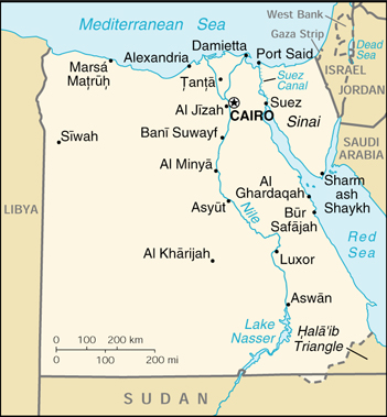
Maps of Egypt
Author: American Geographical Society of New York
Scale: -
Year: 1950
Call Number: G3201.E51 1950 .A4
Language: English
Title: Nile valley, land of the Pharaohs
Author: National Geographic Society (U.S.). Cartographic Division
Scale: 1:1,330,560
Year: 1965
Call Number: G8202.N5 1965 .N3
Language:English
Title: A new map of Cairo
Author: Maktab al-Q¯ahirah lil-Khar¯a’i·t
Scale: 1:14,300
Year: 1966
Call Number: G8304.C2 1966 .M3
Language: English
Title: Alexandria
Author: Lehnert & Landrock.
Scale: -
Year: 1975
Call Number: G8304.A5E635 1975 .L4
Language: English
Title: Tourist map of Cairo
Author: Lehnert & Landrock
Scale: 1:15,000
Year: 1977
Call Number: G8304.C2E635 1977 .L4
Language: English
Title: Ägypten [map] : Strassenkarte mit Sehenswürdigkeiten = Egypt : road map for sightseeing
Author: Kümmerly + Frey
Scale: 1:750,000
Year: 1977
Call Number: G8301.P2 1977 .K8
Language: German
Title: Azimuthal equidistant projection centered on Cairo, Egypt, 30º03’N, 31º15’E
Author: United States. Central Intelligence Agency
Scale: 1:32,400,000
Year: 1985
Call Number: G3201 .B72 1985 .U9
Language:English
Title: Egypt [map]
Author: United States. Central Intelligence Agency
Scale: 1:8,100,000
Year: 1988
Call Number: G8300 1988 .U51
Language: English
Title: Egypt, Sinai Peninsula
Author: United States. Central Intelligence Agency
Scale: 1:2,120,000
Year: 1988
Call Number: G8302 .S5 1988 .U5
Language: English
Title: Egypt, administrative divisions
Author: United States. Central Intelligence Agency.
Scale: 1:8,100,000
Year: 1990
Call Number: G8301 .F7 1990 .U5
Language: English
Title: Egypt [map]
Author: United States. Central Intelligence Agency.
Scale: 1:8,100,000
Year: 1997
Call Number: G8300 1997 .U5
Language: English
Title: Ancient Egypt [map] : great peoples of the past
Author: National Geographic Society
Scale: 1:1,775,000
Year: 2001
Call Number: G8202 .N5 S1 2001 .N3
Language: English
